Mostly cloudy early with thunderstorms developing later in the day. Storms may contain strong gusty winds. High 84F. Winds light and variable. Chance of rain 70%..
Tonight
Scattered thunderstorms during the evening followed by occasional showers overnight. Low 72F. Winds light and variable. Chance of rain 60%.
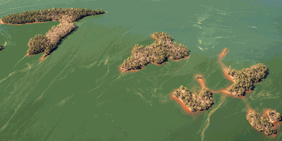
Just as Spain’s Canary Islands archipelago off the southern coast of Morocco sees a lot of cruise traffic, so do Lake Martin’s own Canary Islands north of the Chimney Rock recreational area. With GPS coordinates at 32.72549 and -85.89094, the East Central Alabama Canaries include five irregularly shaped islands immediately south of the point where Blue Creek flows into the Tallapoosa River; in fact, the riverbed flows right through them, separating the archipelago’s largest island from the four smaller ones.
Keep it Clean. Please avoid obscene, vulgar, lewd,
racist or sexually-oriented language. PLEASE TURN OFF YOUR CAPS LOCK. Don't Threaten. Threats of harming another
person will not be tolerated. Be Truthful. Don't knowingly lie about anyone
or anything. Be Nice. No racism, sexism or any sort of -ism
that is degrading to another person. Be Proactive. Use the 'Report' link on
each comment to let us know of abusive posts. Share with Us.
Now, more than ever, the world needs trustworthy reporting—but good journalism isn’t free.
Please support our tireless efforts to gather and report your local news by subscribing or making a contribution.


(0) comments
Welcome to the discussion.
Log In
Keep it Clean. Please avoid obscene, vulgar, lewd, racist or sexually-oriented language.
PLEASE TURN OFF YOUR CAPS LOCK.
Don't Threaten. Threats of harming another person will not be tolerated.
Be Truthful. Don't knowingly lie about anyone or anything.
Be Nice. No racism, sexism or any sort of -ism that is degrading to another person.
Be Proactive. Use the 'Report' link on each comment to let us know of abusive posts.
Share with Us.